N.B Grab yourself a cuppa and settle in, these two posts are pretty long but mainly because we have so many awesome pictures to share!
For our honeymoon adventure back in April, Seb and I cycle toured the Munda Biddi trail in Western Australia. The Munda Biddi trail has been created to mirror the adventure of the famous 1000km hiking trail the Bibbulmun Track, but for mountain bikers. In Noongar Aboriginal language Munda Biddi means ‘path through the forest’. Although the trail is about 1000km in entirety, it is segmented up into very accessible sections each with its own map and a signposted route. A good breakdown is on the official site here, where you can also order the maps. It passes through a town every day and there are also custom built huts along the way which you can use if you aren’t staying in the towns. In all seriousness, in the right weather you could cycle tour this route with just a credit card and a toothbrush! We decided to take all our gear, giving us the option to camp where we wanted or stay in the huts.

In terms of logistics, we chose to fly to the most southern point of the trail in Albany and ride north towards Perth. In the end, this was the best choice as the southern end is by far the most spectacular. We also had a time limit because we had a hire car booked in Perth the following week, so we would aim to see how far we could get in a week.
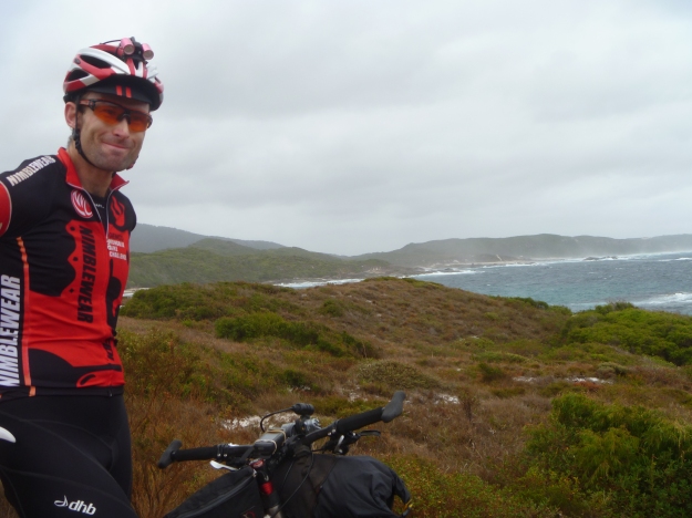
Being true to the trend-setting bikepacking style, we flew to Albany in our bike gear and traveling with only our bike boxes. We found a great spot on the lawn out the front of the airport to build our bikes up, found a big skip to chuck out our boxes and in just over an hour we were on the road into the seaside town of Albany. We dropped into a local bike shop who recommended the best burgers in town, Dylan’s on the Terrace. After great burgers and huge choccy milkshakes we headed off for a quick lap of the headland for some ocean views. It was really hot and the ocean was aqua blue so we talked about going for a swim at the beach. That idea was quickly shelved when we got to the beach as a bulldozer was putting a washed up dead whale into a truck. The whale had attracted large sharks in the area, the beach was closed and it even made the news!

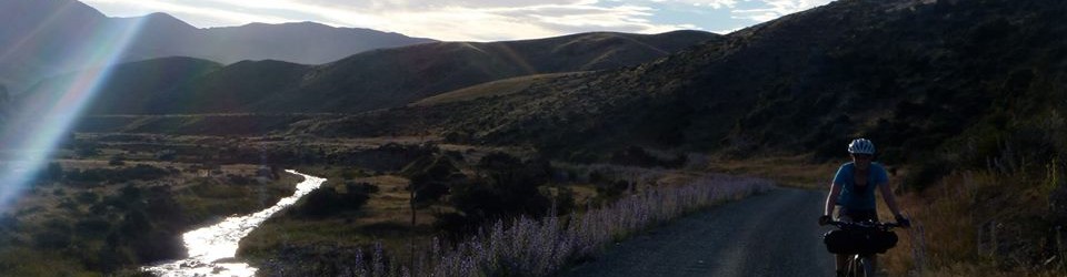
Swimming aborted we decided to get on our way for the day. We rode fun single and double track through very dry bush. The colours were just beautiful: orange gravel, green and black grass trees, red gum blossoms and a vivid blue sky. We didn’t really have a plan for the afternoon as we probably wouldn’t make the first huts or town before dark, so we just took it in and enjoyed the ride. Camping was meant to be nice at Cosy Corner, but we were riding well and totally overshot the turnoff. In the end we stopped around at a little spot on the edge of the Wilson Inlet. On dusk we were greeted, to our surprise, by a car full of guys who were fishing at the river mouth. Luckily they weren’t 30 minutes earlier to witness our nude bathing! We didn’t sleep well, the 1.5-man tent isn’t the best size for two of us tall people and when I get hot I tend to dream more. A restless night for us was made worse for me by a horrible nightmare, leaving me drenched in sweat. Eeww.


 Day 1 stats: 89km, 575m vert. (Strava Day 1)
The next morning we packed up and rode the last hour of rail trail into Denmark for breakfast. There is something both pleasant and rewarding about riding before breakfast, but mainly I guess it is just the lessened guilt one gets when ordering food bikepacking style. We found a fantastic little cafe called Mrs Jones cafe at the Old Butter Factory Galleries with fresh yum food and free wifi – highly recommended!
Once we had restocked at the Super IGA with supplies, we we off towards the coast. This section of the trail was one of my most favourite parts of the trip. A winding iron ore gravel path had been hacked through the thick scrub and white sand that lined the southern coast. It is wider than singletrack but smooth and flowing and occasionally emerged above the scrub and treated us to views of the wild and windy coast. It reminded me very much of a place we rode to in Wildside stage race, Granville Harbour on the west coast of Tasmania.


The next section of riding was not so great as there was a long detour (marked) on bitumen and the roads were a bit boring. Once back on the dirt we enjoyed some super fast firetrail and then some hilarious ‘track’ to get to our lunch spot at the fantastic Jinung Beigabup campsite. These purposely built campsites have camping spots, open bunk houses, tables, bike racks, pit toilets and the best bit is that they are off the road and only accessibly by foot or bike, not car! While eating lunch we discovered that the campsite log book would prove to be great entertainment each day: a few tales of woe but mainly stories of others thoroughly enjoying themselves.

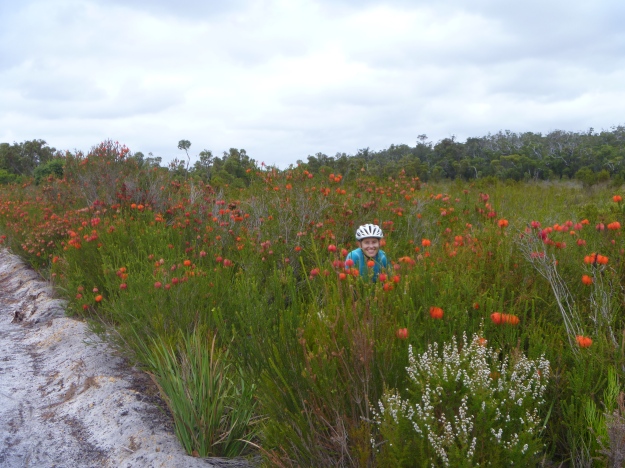
 For the past day and a bit we had been riding past some beautiful red flowers that were a kind of bottlebrush but not familiar to me. I kept asking if we could stop and get a photo but by the time I saw them they were gone before I could be bothered to get the camera out. The next section to Booner Mundak campsite however, proved to be too spectacular for me to resist, and stop I did. Many times!


Eventually, the road into Booner Mundak campsite turned to crap and the last 4km were just sand. I found riding on the sand hard and walked a fair bit but Seb rode the whole stretch, except this tiny bit which I got a photo of and he says that isn’t fair! But with salami and cow cheese wraps in our tummies, we were ready for bed after a decent day of riding. We shared the camp with an older couple from Berowra NSW and another couple of very loud and grumpy men arriving after dark, with bob-trailers and swearing about sand, sand, sand. Again I hardly slept a wink, this time the fat men were rustling around, tossing and turning and all I wanted was to go sleep outside.


Day 2 stats: 112km, 1226m vert. (Strava Day 2)
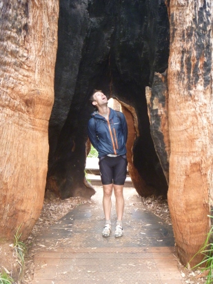
On a crisp and sunny morning, day three, we set off back to the sandy road for sand, sand and more sand. It was perfect weather for arm warmers… but I had left mine hanging over the bunk ladder back at camp. Afraid of getting scolded by an angry I-told-you-so Seb, I braved it with bare arms or rain jacket for the rest of the trip! Eventually we started to gain some height and climb into the Valley of the Giants. First stop was the Tree Top Walk near Walpole, which we thought might have opened at 8am but it turned out to be 9am. It was a great attraction and even by 9am there were plenty of people buzzing around. The highest point of the suspension bridge walk takes you 40 meters off the ground and there are still trees towering above you. I am very afraid of heights and I wasn’t super keen walking around in mtb cleats over a metal mesh, but it was totally worth it! And it was even possible to put Seb in a picture with something that dwarfed him in size for once!


The ride into Walpole was also stunning. We continued on through towering Tingle, Jarrah and Karri forest, straining our necks to see the tree tops. It was pretty lumpy terrain with bark and leaf litter fire trails intermixed with some totally rad singletrack sections which eventually popped us out onto the more sandy flat land around Walpole. We stopped for an early bakery lunch in the park, obligatory iced coffees and set off in soaring temperatures and sun.

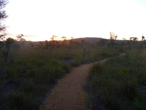
The afternoon was hot, dirty and hard work. By the time we had pushed through to Fernhook Falls we decided it was definitely time for a swim to get rid of three days of grub. It was a magic little spot but we decided to push on into the sunset and try and make Yirra Catta campsite just after dark. It was gorgeous riding into the sunset, the best we could do for our romantic honeymoon!

 We arrived just after dark at Yirra Catta campsite, where we stayed with another cyclist who was touring the trail south by himself. He noted that the gravel started getting worse further north and hinted towards the most northern part of the trail being the part to miss if we bailed early. Good to get news about the trail in the other direction, so we kindly told him about the sand!
Day 3 stats: 124km, 2201m vert. (Strava Day 3)
End of day three and still happily married… good news. Time to top up your cuppa for Part 2.
